


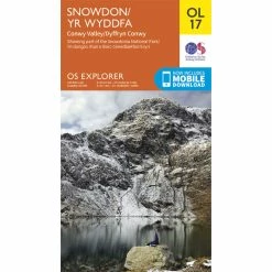

Ordnance Survey OL17 Snowdon/Yr Wyddfa Map
Den oprindelige pris var: 7,43 €.5,20 €Den aktuelle pris er: 5,20 €.
- Oplev kvalitet, shop hos os
- Ekspert indkøbt, kvalitetsgaranti
- Naturvenlige materialer, for en bedre planet.
- Få de bedste tilbud

A go-to guide for exploring the wonderful outdoors, the Ordnance Survey OL17 Snowdon/Yr Wyddfa Map features highlights of Conwy Valley, Dyffryn Conwy and more. Plus, it includes a free digital download.
An essential addition to your outdoor adventure kit, the Ordnance Survey OL17 Snowdon/Yr Wyddfa Map provides directions and key information of hotspots in Conwy Valley, Dyffryn Conwy and its surrounding areas.
About OS Explorer Maps
The OS Explorer Map is the Ordnance Survey’s most detailed folding map and is recommended for anyone enjoying outdoor activities including walking, horse riding and off-road cycling. Providing complete GB coverage, the OS Explorer Map series details essential information for the great outdoors, including youth hostels, pubs and visitor information. Rights of way, fences, permissive paths and bridleways are clearly shown, ensuring you have the most up-to-date information to get the most out of your time in the countryside.
OL17 Snowdon/Yr Wyddfa Map features:
North Wales Path, Isle of Anglesey Coastal Path / Llwybr Arfordirol Ynys Mon, Bangor, Betws-Y-Coed, Caernarfon, Conwy, Llandudno, Snowdonia National Park, Gwynedd, and Clwyd.
Topfunktioner:
- Topographic mapping: Highly detailed contour mapping highlighting variations in terrain and everything you would expect from a map
- Explore local landmarks: Discover camping sites, picnic spots, tourist information, car parks, historical sites, pubs, and much more
- Be ready for anything: Find marked public rights of way, byways, trails, cycle routes, bridleways, road networks, and railway lines
- Scale: 1:25 000 (4 cm to 1 km – 2.5 inches to 1 mile)
- FSC certified; 100% recyclable; Sustainable packaging
- This map also comes with a digital version you can download to your smartphone or tablet; To download, scratch off the panel on the inside cover of the map to reveal a code and go to OS.uk/redeem for more details (terms and conditions apply)
| Vælg en størrelse | One Size |
|---|
Vær den første til at anmelde “Ordnance Survey OL17 Snowdon/Yr Wyddfa Map”
Relaterede varer

Hydreringspakker og løsdele
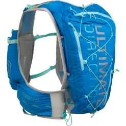
Ultimate Direction Women’s Ultra Vesta 5.0 10L Hydration Vest


Flaskeholdere


Cykellåse


Stelbeskyttelse


Cykelskærme
Anmeldelser
Der er endnu ikke nogle anmeldelser.